Striking satellite images show huge ‘unprecedented’ wildfires across the Arctic, Siberia, and Greenland amid unusual heat wave
- Wildfires continue to rage across Siberia, the Arctic, and Greenland due to temperatures as high as 90F
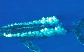
- Striking images of the fires were created by Pierre Markuse and show the breadth of the blazes
- Fires are now plentiful and large enough that the equal Lanzarote, an island in the Atlantic Ocean, in size
- Smoke and ash from the fires endangers human health and also threatens to increase snow and ice melt
Advertisement
Stretches of the Arctic, Siberia, and Greenland are going up in flames after a rash of wildfires fueled by unusually hot temperatures.
The blazes have been documented by imaging expert, Pierre Markuse, who transforms grainy raw satellite images into high-fidelity snapshots.
The shots reveal the breadth of fires which are blanketing expanses of wilderness under shrouds of smoke. According to the World Meteorological Organization (WMO), the scope of Arctic wildfires are ‘unprecedented,’ with the agency logging more than 100 intense fires throughout the Arctic Circle.
Climatologists warn the biggest risk of the fires is to the snow and ice: as fires rage, permafrost melt can accelerate causing glaciers to fall into the ocean.
In addition to contributing to sea level rise, experts warn that methane gas trapped in the ice will also be released by the ice melt, further compounding the problem.


Pierre Markuse uses a number of techniques to enhance satellite images. The results are high fidelity portraits of Earth’s landscape and the natural events that shape it.
‘Although wildfires are common in the northern hemisphere between May and October, the latitude and intensity of these fires, as well as the length of time that they have been burning for, has been particularly unusual,’ said the WMO in a statement.
Fires have been raging the hardest in the Arctic and Siberia says the WMO, and are now big enough to constitute 100,000 football pitches or roughly the size of Lanzarote, an island in the Atlantic Ocean.
This month, temperatures hit record highs for Alaska, soaring to 90 degrees Fahrenheit on July 4 fueling fires along the Yukon River and the Arctic Circle.
‘Alaska has just come to the end of a period of warmth that re-wrote the record books for multiple cities and communities across the state. And crazy enough, it was one of several jaw dropping climate events taking place across our largest state,’ wrote the National Oceanic and Atmospheric Administration in a recent blog post.
In Greenland, fires were observed up last week, marking the second time in three years that wildfires have been witnessed there. As reported by Gizmodo, there is very little historic precedent for fires emanating from the typically icy territory.
Risks of additional fires in Greenland remain high to very high throughout the next week.
In addition to blanketing the region in smoke and razing acres upon acres of trees, wildfires also pour significant carbon into the Earth’s atmosphere.
That carbon can have substantial impacts on climate change says the WMO. In 2014 fires in Canada burned more than 7 million acres of forest and released more than 103 million tons of carbon into the atmosphere alone.
According to NASA, that’s half as much carbon as all the plants and trees in Canada typically absorb in an one year.

Fires have spread across the region to record temperatures. On July 4, temperatures reached 90 degrees in Alaska for the first time ever.

Smoke not only endangers people’s respiratory health, it can blanket ice and snow in the Arctic, leading to increased melt.
Humans are also at immediate risk when it comes to wildfires – even those that live far away from where the blazes continue to smolder.
‘In addition to the direct threat from burning, wildfires also release harmful pollutants including particulate matter and toxic gases such as carbon monoxide, nitrogen oxides, and non-methane organic compounds into the atmosphere,’ said the WMO.
‘Particles and gases from burning biomass can be carried over long distances, affecting air quality in regions far away.’
HOW ARE WILDFIRES STARTED?

The amount of land in North America devastated by wildfires each year is set to rise, according to new research (file photo)
The ‘Thomas Fire’ destroyed 281,893 acres in California last December.
Additionally, British Columbia’s Nazko Complex Fire last year consumed more than a million acres, making it the largest ever recorded in the province.
But the amount of land destroyed by wildfires each year will only go up in western and northern North America in the years to come, according to a new report published in the journal Plos One.
Up to 90 percent of US wildfires are caused by people, according to the Insurance Information Institute.
These fires can be initiated by unattended campfires, piles of burning debris, haphazardly discarded cigarettes or arson.
The remaining tenth of wildfires not started by humans are attributed to either lighting or lava.


