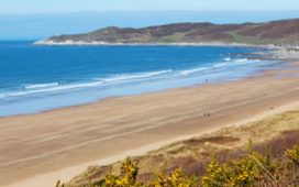
I meet Richard Warren from Wasdale Mountain Rescue at the most appropriate place, a pub adorned with photographs of people in farcically inadequate clothing, carrying outdated equipment while they tackle monstrously dangerous crags not far from where we sit.
The only feeble excuse these poor folk can offer is that they lived between the birth of mountain photography (around the 1870s) and the formation of mountain rescue teams (around 1928), in an age when a woman’s best friend on a mountain was a full-length tweed skirt and emergency rations meant a twist of rough shag for your pipe. The Wasdale Head Inn is set far up the loneliest dale under the grandest mountains in England, and its wall, you understand, is a photographic testament to the early days of learning how to survive out there.

My mission is to tackle some of the best ridge walks in Britain and I’m keen to hear Richard’s advice. With sustained views on both sides of the path, ridges can be exhilarating, but in bad weather they can also become dangerous.
I ask him for his favourites. “Aonach Eagach in Glen Coe – that’s extraordinary, intense. Crib Goch on Snowden, of course – a real challenge and not to be underestimated.” Understandably, he also has many favourites in the Lake District: the three edges, Striding, Swirral and Sharp, plus the one I am attempting tomorrow: the Mosedale Horseshoe.
Mountain Rescue is getting busier, he says, as more people try hill walking for the first time, and fatalities keep happening: 17 in the Lake District in 2019, 21 the year before. “We calculate that a third of all call-outs could be avoided,” he adds.

“People make simple errors: they take a mobile phone instead of a map, then the battery runs out. They set off too late. They split their group then someone gets lost. We have a new website, Adventure Smart, which gives up-to-date weather reports and good advice, and that seems to be helping.”
Given that I am attempting the Mosedale Horseshoe in winter with my partner Sophie, who has a foot injury, and an ageing dog who has a mistaken belief that he is as young as he used to be, I take careful notes. Check weather (especially the wind chill and freezing level – the altitude above which to expect ice and snow), leave word, carry a paper map, gloves, hat, torch plus plenty of food and drink. As we leave the inn next morning I can see lacy fringes of snow adorning the mountains below the ominously heavy cloud. I cannot, however, see the Mosedale Horseshoe.
I use the map immediately to ensure we take the right path up Mosedale. There are no signposts on the fells – a fact that can fuddle even experienced walkers if they’re from areas where footpaths are generously marked.
“When there’s no sign, people tend to follow each other,” Richard had said the previous evening. “That’s how an inexperienced group can follow an experienced group on to a path that is way beyond their abilities.”
There’s no chance of that mistake today. We are alone. At Black Sail Pass, our entry point on to the ridge, we pause and assess the situation. The cloud is not breaking up, as was forecast, and occasional showers of hail are stinging our faces in a stiffening wind. We start up the ridge and finally get our reward: a brief sunny view north to Scotland across the Solway Firth, with a pearly string of lakes to the south.
By the time we reach 892-metre Pillar, however, we are in cloud and the wind gets nasty. We huddle behind a rock for lunch and decide to head back. We retrace our route, reaching the inn in darkness. In some ways, my first ridge walk has been frustrating, but at least I didn’t meet Richard again, in his mountain rescue role.
Grade: in good weather the Mosedale Horseshow is a straightforward hike
Start: Wasdale Head Inn
Map: OS Explorer OL4
Distance: 11 miles
Dog-friendly: yes
Public transport: nearest station is Seascale (on the Carlisle to Barrow-in-Furness line), a half-hour taxi ride away
Lake District: Striding Edge/Helvellyn

Grade: a good level of fitness needed
Start: Glenridding
Map: OS Explorer OL5
Distance: 9 miles
Dog friendly: sensible hill hounds only
Public transport: 508 bus from Penrith (can also combine with Ullswater steamer)
Like Crib Goch and Tryfan in Snowdonia, the Lake District’s Striding Edge is definitely one of those ridges that a walker can fall off. However, if being careful to avoid ice, wind or darkness, there is no reason not to enjoy a magnificent day out. I first tackled it aged 11; Wilf my dog managed it as a puppy and celebrated with his first-ever swim – in Red Tarn, the chilly little glacial lake under the summit of Helvellyn. This time he is older and wiser: we go up via Striding Edge and come down via its neighbour, the equally demanding Swirral Edge, but he does not swim. Nor do I. Instead, we yomp briskly to my favourite tearoom in Glenridding (the Helvellyn Country Kitchen) and warm up. For sheer spectacular lakeland panoramas, the Striding/Swirral combo is unbeatable.
Lake District: Sharp Edge

Grade: straightforward in good conditions/challenging when poor
Start: park in Scales or Threlkeld
Map: OL5
Dog-friendly: sensible hill hounds maybe. I didn’t risk it
Distance: 4½ miles
Public transport: X4 or X5 bus from Penrith/Keswick
Another one to avoid in a high wind, but Sharp Edge is also a classic, all the better for being quieter than Helvellyn. The main peak on this route is Blencathra at 868 metres , which has satanic associations: one etymology of the name is “summit of the devil”. I personally think it’s a little easier than Striding Edge, being shorter, but a lot depends on conditions. If things look dodgy, there is an easy deviation that misses out the worst (or best) bit of the ridge. Start at Scales Farm heading up the hill northwards, climbing to Mousthwaite Comb to get the first view – hopefully – of Sharp Edge. Negotiate that, then Foule Crag and reach Blencathra summit. WalkLakes.co.uk has a similar, longer route, taking in Mungrisdale Common.
Crib Goch, Snowdonia

Grade: Extreme. Take a guide if unsure.
Start: Pen-y-Pass
Map: OS Explorer OL17
Distance: 7½ miles
Dog friendly: No
Public transport: Sherpa bus S2 from Betws y Coed
I leave Pen-y-Pass at 7am for this one (after claiming the last spot in the car park: be warned!) and take the Pyg track for a short ascent before branching right on to the ridge. Crib Goch is certainly not one for the faint-hearted. This is a walk with remarkable views, often of your white knuckles as they cling to the precarious central line of the ridge. Once that section is managed, there is a serious sting in the tail to negotiate: Garnedd Ugain (1,065 metres), next to Snowdon, a tumble of rocky outcrops where the path is difficult to follow and a moment’s inattention can have painfully nerve-wracking consequences when negotiating broken buttresses and small cliffs. I emerge on the cinder track that follows the railway to Snowdon’s summit – and the cafe. From here, I take the path down to the jagged crest of Y Lliwedd, then descend to the small glacial lake – Llyn Llydaw – enclosed by the two ridges, picking up the Miner’s Track to return to the Pen-y-Pass car park. There is an excellent Youth Hostel right next to it.
Tryfan north ridge, Snowdonia

Grade: Difficult, prior mountain experience required
Start: long version Pen y Pass, shorter Idwal Cottage
Map: OL17
Distance: long 11 miles/short 3 miles – lots of variants possible
Dog-friendly: not unless you can pop the pooch in the backpack
Public transport: Sherpa bus S2 (for Pen y Pass) or 6B (summer only to Llyn Ogwen)
Make a weekend of it in the Youth Hostel at Pen y Pass, doing Crib Goch one day then the less-visited ridge of Tryfan that sits to the north. Head up to the summit of Glyder Fawr, which made headlines in 2010 when it was upgraded from a measly 999 metres to a commanding 1001. From here there’s a circuit of ridges and descents that goes (in anti-clockwise order): Glyder Fach (994), Bristly Ridge, Tryfan north ridge which ends, if doing this direction, at the Cannon Stone, a popular photo opportunity. From here, the normal way curls around Milestone Buttress and down to Llyn Ogwen where there’s a cafe: the Ogwen Snack Bar, in the village of Idwal Cottage. There’s a car park and, for those just wanting to do the north ridge, it’s a three-mile walking circuit from here. On a long summer day, however, the big route is possible, returning to Pen y Pass via Llyn Ogwen and Glyder Fawr.
Glen Coe/Aonach Eagach

Grade: extreme. Take a guide if unsure
Start: Meeting of Three Waters A82
Map: OS Explorer 384
Dog-friendly: no
Distance: 9 miles for the full circuit, 6 miles without the road section
Public transport: Scottish Citylink 915
To be honest, Scotland has so many great ridge walks that picking one seems ridiculous, but Aonach Eagach is the one I know best; besides, it also has the reputation of being the narrowest ridge walk in Britain, any more knife-like and it would have to be classified as a tightrope. For that reason, wind, weather and season are crucial in planning the day, but the reward is a fabulously exciting day out. The path starts at the parking area by the Meeting of Three Waters waterfall close to the A82 (four miles east of Glencoe visitor centre). It ascends rapidly to the 943-metre peak of Am Bodach, where things immediately get more challenging with a tricky descent to a col (some people use a rope on this bit). From here, climb to Meall Dearg and then comes the highlight, the Pinnacles section which is about 500 metres long. Things ease off a bit to another Munro, Sgorr nam Fiannaidh (967 metres), from whence you descend back down into the valley where the Old Glencoe road leads to the Clachaig Inn for a well-earned pint. Unless using two cars or taking the bus, there’s then a three-mile yomp back up the road to the starting point.
Stiperstones, Shropshire

Grade: Easy
Start: the Bog car park, Stiperstones Inn or Bridges YHA
Map: OS Explorer 217
Distance: 8 miles or 4.5 miles without The Rock
Dog-friendly: yes
Public transport: train to Church Stretton (5 miles away) or 552 bus from Shrewsbury to Stiperstones Inn. There is also a useful weekend summer bus for the area
Shropshire’s hill walks are not as famous as those of the Highlands or the Lakes, but Stiperstones is one of the best: a jagged dragon’s back that stretches north-south in parallel with another good ridge, the Long Mynd. By adding on two more outlying outcrops, Nipstone and The Rock, the Stiperstones becomes an eight-mile round trip. The views are spectacular, the kind of thing that might have inspired JRR Tolkein’s Shire: rolling green hills dotted with ancient trees, stepping back in waves to a purple horizon. I hope the path along the ridge was not purpose-built because it’s a tricky potential ankle-breaker of irregular stones winding through heather between each of the Stiperstones, six outcrops of quarzite rock that date back half a billion years. Like any self-respecting geographical feature in this area, Stiperstones claims legendary connections to both the devil and King Arthur. After an hour scrambling on the slippery boulders, I accept unreservedly the satanic association. I return via the lower-level route on the eastern side. All this hard work, however, is amply rewarded with a visit to one of the lovely small towns nearby: Church Stretton, Bishops Castle and, my choice, Montgomery, where the The Checkers serves particularly excellent tea and cakes.
Looking for a holiday with a difference? Browse Guardian Holidays to see a range of fantastic trips
This article contains affiliate links, which means we may earn a small commission if a reader clicks through and makes a purchase. All our journalism is independent and is in no way influenced by any advertiser or commercial initiative. By clicking on an affiliate link, you accept that third-party cookies will be set. More information.