
In Laramie, Wyoming, long-haul trucks roar along Interstate 80, a transportation backbone that stretches from San Francisco to just outside New York City. Traffic is so heavy here that the state’s transportation department recently counted a passing vehicle every 10 seconds, on average.
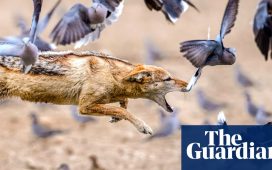
But this vital, four-lane corridor of commerce threatens wildlife. It blocks the ancient north-south paths of mule deer, elk and pronghorn, creatures that embody the American west. Animals that try to complete annual migrations, which their species have made for thousands of years, risk deadly encounters with passenger cars or 18-wheelers.
As the climate changes, altering where animals graze and find suitable habitats, migration corridors are more important than ever to their survival.
“We can’t predict exactly what the impacts of climate change are going to be, or what species are going to be impacted,” says Hall Sawyer, a research biologist at Western Ecosystems Technology. “We do know one fundamental truth: that if we can keep this landscape connected, improve that permeability, they’ll be better off.”
So Wyoming officials and scientists have a plan: to build wildlife crossings to preserve migrations. Bridges, tunnels and other structures – imagine protected bike lanes, but for animals – can protect animals from hazards such as highways and help them navigate a warming planet.
For the female pronghorn known to researchers as 700031A (or Sally), the valley in western Wyoming is a paradise in summer. It surrounds a horseshoe lake that curves through the Wind River Range mountains. Sagebrush and mountain flowers, mixed with aspen trees, grow on the valley slopes. The vegetation the pronghorn eats here will help fuel her 150-mile migration south, a journey longer than the distance between Washington and Philadelphia. She leaves in September, before winter snow buries edible plants and forms dangerous drifts.
Sally follows a route walked by generations of pronghorn. Bones discovered in Wyoming suggest that pronghorn used nearby migration corridors for at least 8,000 years, says Greg Nickerson, a writer and filmmaker for the University of Wyoming’s Wyoming Migration Initiative. The pronghorn lineage in America stretches back 20 million years. Their ancestors endured nearly cataclysmic disasters, such as a Yellowstone super-volcano eruption that blanketed the West in ash about 640,000 years ago.
Researchers placed a GPS collar on the pronghorn in February 2018, giving her a number instead of a name, to preserve their scientific detachment. Since then, Sawyer, who studies migration patterns, has monitored her movements. As the pronghorn heads south to a milder winter habitat, she nears Highway 191, where tall fences corral her to a crossing site. She walks across an overpass named Trappers Point, a gentle hump of bridge designed for animals completed in 2012.
“We know that pronghorn and mule deer have been using that overpass,” says University of Wyoming graduate student Benjamin Robb, who watched Sally’s movements on a computer screen in his Laramie office. “But seeing a collared animal using it is really cool.”
The pronghorn skirts to the west of two gas fields. “She’s actually avoiding all the infrastructure,” says Sawyer, who believes she is an adult between six and eight years old. She moves swiftly, travelling several miles a day, until she reaches the Green River. The water level drops in the fall, so she probably wades across, he says.
The coffee-colour pronghorn, following a narrow band of sagebrush, crosses two more highways. She navigates these roads without using wildlife bridges, walking along the edge of the fenced-off solar farm “smack dab in the middle” of the migration corridor, Robb says. By early November, Sally had arrived near Wyoming’s southern lip. Here, this descendant of super-volcano survivors encountered a new kind of obstacle: Interstate 80. The superhighway stopped her in her tracks.
I-80 began killing wildlife even before it opened in 1970. As archivist John Waggener writes in Snow Chi Minh Trail, his history of I-80 named after a particularly perilous section of the road, construction crews collided with wildlife as early as 1967. “They keep running into wildlife, and so the engineers and the road planners realise that they are building this highway smack-dab in the middle of a fairly major migration corridor,” Waggener says.
He was a passenger in a vehicle that struck a pronghorn on I-80 during a whiteout blizzard in the late 1980s. The humans were fine; the animal was not.
of vehicle collisions in Wyoming involve wildlife
In Wyoming, 15 per cent of all vehicle collisions involve deer, antelope or other big game animals, says Corinna Riginos, director of science at the Nature Conservancy’s Wyoming field office. These 6,000 annual collisions cause $50m (£40m) of damage to cars and loss of wildlife. In 2017, a semi-trailer truck killed 25 pronghorn on I-80 when the truck ploughed into a herd.
As the highway neared completion, engineers dug underpasses below I-80 to allow animals to cross. Their motivations were sound. “If you were to install highway underpasses or overpasses and fencing on a segment of road,” Riginos says, “we know from many, many studies and data sources that that is going to reduce the number of collisions.” A study of the Trappers Point overpass and nearby underpasses found that collisions with mule deer dropped by 79 per cent and that those with pronghorn stopped completely.
But without accurate migration data, the first culverts were constructed in the wrong places. Few animals used them. Mule deer and other grazers that migrate in Wyoming follow spring vegetation. Migration is not a journey between two endpoints; migration is the point – the animals eat their way along the path, scientists say.
In what biologist Matthew Kauffman calls “surfing the green wave”, migrating animals spend the spring eating plants that sprout first at low elevations. The deer then follow the foliage as plants appear along the slope to higher elevations. Kauffman and his colleagues are only beginning to understand how warming temperatures can disrupt the green wave. In drought years, the wave is much harder to surf, he says.
1/20 California
In this decade, humans have become ever more aware of climate change. Calls for leaders to act echo around the globe as the signs of a changing climate become ever more difficult to ignore
Getty
2/20 Athens, Greece
Fierce wildfires have flared up in numerous countries. The damage being caused is unprecedented: 103 people were killed in wildfires last year in California, one of the places best prepared, best equipped to fight such blazes in the world
AFP/Getty
3/20 Redding, California
Entire towns have been razed. The towns of Redding and Paradise in California were all but eliminated in the 2018 season
AP
4/20 Athens, Greece
While wildfires in Greece (pictured), Australia, Indonesia and many other countries have wrought chaos to infrastructure, economies and cost lives
AFP/Getty
5/20 Carlisle, England
In Britain, flooding has become commonplace. Extreme downpours in Carlisle in the winter of 2015 saw the previous record flood level being eclipsed by two feet
AFP/Getty
6/20 Hebden Bridge, England
Hebden Bridge in West Yorkshire has flooded repeatedly in the past decade, with the worst coming on Christmas Day 2015. Toby Smith of Climate Visuals, an organisation focused on improving how climate change is depicted in the media, says: “Extreme weather and flooding, has and will become more frequent due to climate change. An increase in the severity and distribution of press images, reports and media coverage across the nation has localised the issue. It has raised our emotions, perception and personalised the effects and hazards of climate change.”
Getty
7/20 Somerset, England
Out west in Somerset, floods in 2013 led to entire villages being cut off and isolated for weeks
Getty
8/20 Dumfries, Scotland
“In summer 2012, intense rain flooded over 8000 properties. In 2013, storms and coastal surges combined catastrophically with elevated sea levels whilst December 2015, was the wettest month ever recorded. Major flooding events continued through the decade with the UK government declaring flooding as one of the nation’s major threats in 2017,” says Mr Smith of Climate Visuals
Getty
9/20 London, England
Weather has been more extreme in Britain in recent years. The ‘Beast from the East’ which arrived in February 2018 brought extraordinarily cold temperatures and high snowfall. Central London (pictured), where the city bustle tends to mean that snow doesn’t even settle, was covered in inches of snow for day
PA
10/20 London, England
Months after the cold snap, a heatwave struck Britain, rendering the normally plush green of England’s parks in Summer a parched brown for weeks
AFP/Getty
11/20 New South Wales, Australia
Worsening droughts in many countries have been disastrous for crop yields and have threatened livestock. In Australia, where a brutal drought persisted for months last year, farmers have suffered from mental health problems because of the threat to their livelihood
Reuters
12/20 Tonle Sap, Cambodia
Even dedicated climate skeptic Jeremy Clarkson has come to recognise the threat of climate change after visiting the Tonle Sap lake system in Cambodia. Over a million people rely on the water of Tonle Sap for work and sustinence but, as Mr Clarkson witnessed, a drought has severley depleted the water level
Carlo Frem/Amazon
13/20 Addis Ababa, Ethiopia
In reaction to these harbingers of climate obliteration, some humans have taken measures to counter the impending disaster. Ethiopia recently planted a reported 350 million trees in a single day
AFP/Getty
14/20 Morocco
Morocco has undertaken the most ambitious solar power scheme in the world, recently completing a solar plant the size of San Francisco
AFP/Getty
15/20 London, England
Electric cars are taking off as a viable alternative to fossil fuel burning vehicles and major cities across the world are adding charging points to accomodate
AFP/Getty
16/20 Purmerend, The Netherlands
Cities around the world are embracing cycling too, as a clean (and healthy) mode of transport. The Netherlands continues to lead the way with bikes far outnumbering people
Jeroen Much/Andras Schuh
17/20 Xiamen, China
Cycling infrastructure is taking over cities the world over, in the hope of reducing society’s dependency on polluting vehicles
Ma Weiwei
18/20 Chennai, India
Despite positive steps being taken, humans continue to have a wildly adverse effect on the climate. There have been numerous major oil spills this decade, the most notable being the BP oil spill in the Gulf of Mexico in 2010
AFP/Getty
19/20 Amazon rainforest, Brazil
More recently, large swathes of the Amazon rainforest were set alight by people to clear land for agriculture
AFP/Getty
20/20 California
This decade may have seen horrors but it has led to an understanding that the next decade must see change if human life is to continue
Getty
But a migration corridor that is expansive enough and free of obstacles offers animals a chance to survive a warming planet. “That 150-mile migration? That animal has a 150-mile foraging template tonmitigate the effects of climate change,” Kauffman says.
I-80 runs for 400 miles through southern Wyoming. A railroad, another obstacle to wildlife trying to move north and south, runs parallel to the interstate for miles.
Animals travelling south for the winter are forced to stop when they reach I-80, which runs east-west through Wyoming’s Red Desert. In the summer, mule deer will travel more than 100 miles to the Hoback Basin, following a migration corridor that Sawyer discovered. Thousands of deer eat their way along this path.
Fences protect motorists from wildlife attempting to cross roads. Although fences deter animals, some make it through by vaulting over the barriers. Others end up tangled in the fencing; those that cannot pull free die.
But I-80 is such a strong barrier that pronghorn are “over a thousand times more likely to successfully cross a fence than this interstate,” Robb says. One afternoon last month, Nickerson counted seven dead mule deer on a 100-mile stretch of the interstate between Rawlins and Laramie. At the point where it bends around Elk Mountain, I-80 becomes a roadkill hot spot. There, at Halleck Ridge, a proposed crossing site for deer and elk, the Wyoming Department of Transportation tallies about 25 roadkill carcasses per year.
Wildlife will use some underpasses on I-80. In one of these boxy concrete tunnels, birds made mud nests stuck to the walls. In late January, Nickerson’s cameras recorded a small herd of deer as they marched below the highway. Given the varying lengths of the country’s corridors, scientists are trying to determine whether they provide a way for wild species to outrun the climate crisis.
Jenny McGuire, an expert in spatial ecology, worked with Georgia Tech colleagues to develop a model that divided the American landscape into hot and cool habitats.
“We said: ‘OK, what’s the coolest place that something can get to, by moving through connected, adjacent natural land areas?’” McGuire says. They predicted the most sensible paths animals would take to navigate fragmented habitats, avoiding urban areas in favour of land with little or no human development.
The researchers reported in a 2016 paper that 41 per cent of the wild habitats in the United States would allow species to maintain their preferred temperatures over the next 100 years of warming, assuming a global increase of 2.7C over that time. But, if those habitats were connected by wildlife corridors, 41 per cent jumps to 65 per cent, McGuire and her colleagues found. North-south movement is critical, but so is elevation. One estimate projects that wildlife would have to travel nearly 250 miles towards the poles to escape an overall 5F temperature increase. Or they could run 500 yards up a mountain.
The Nature Conservancy is mapping habitats that, its conservationists predict, will allow Wyoming’s wildlife to move into new ranges as the climate changes. Researchers already know that deer “migrate from low to higher elevation areas every year”, Riginos says. “And, in the future, other species may need to shift their ranges to the same higher elevation areas.”
Ecological connections serve two purposes: they allow individuals to survive by providing more space to roam, access to food or a bigger mating pool. And they enable animals to relocate in the long term. “If you establish a permanent corridor, it’s important for both needs,” McGuire says.
After linking football-field-size sections of longleaf pine savanna, a rare habitat in South Carolina, ecologists have seen the diversity of plant species balloon since 2000.
Last year, scientist Jodi Hilty and her co-authors updated their textbook on corridor ecology. In the 13 years since the first edition, they found 183 new papers on connectivity and climate change. “The field literally exploded,” she says.
There are some concerns that corridors could help spread invasive species or wildfires. “But the preponderance of evidence – and, certainly, the recommendations resounding from the climate change science community – show that connecting these remaining wild areas is a very sound approach,” Hilty says.
One of the best-regarded experimental studies of climate and connections took place a decade ago in a forest in northern Quebec. There, researchers tweaked the moisture and temperature in the habitats of tiny mites that live on moss patches. Some pieces of moss were connected, creating a corridor. Biodiversity plummeted in the dried-out habitats, as McGill University biologist Andrew Gonzalez and his co-authors showed in a 2012 paper.
the distance wildlife would need to travel to escape temperature increase
But linking the “carpets of mosses”, as Gonzalez described them, helped preserve some of the richness of the mite species. “Extinction rates are slowed and colonisation rates increased,” he says. The study of corridors and migration has evolved, thanks to high-quality GPS data. Scientists can track the movements of animals in real time and use that information to help identify where to establish the best road crossings.
That revolution also allowed University of Wyoming biologists to track record-setting animals, such as mule deer 255. The animal’s one-way, 242-mile trek from Idaho to Wyoming is the farthest ever recorded for a deer walking in the lower 48 states.
Yellowstone to Yukon, also known as Y2Y, is one of the most ambitious corridor projects on the continent. The project, begun in 1993, aims to protect a 2,000-mile stretch of habitat in North America from Wyoming to the Arctic Circle. Yellowstone to Yukon’s conservationists have supported highway overpasses, helped track wolverines and purchased more than 500,000 acres of land to preserve wildlife routes.
The project is “really incredibly useful for the northwestern portion of the United States”, says McGuire, the Georgia Tech ecologist. Yellowstone’s grizzlies, for instance, aren’t especially genetically diverse, Hilty says. Breeding with Canadian bears could help their cubs resist disease or gain other beneficial traits.
Corridor and connectivity projects have sprung up across the country: in Los Angeles as a bridge for mountain lions, below Florida highways as structures for panthers and alligators, and in the Capitol as legislation. Last year, Rep Don Beyer reintroduced the Wildlife Corridors Conservation Act, which has bipartisan support.
The bill would authorise $50m in grants for the national corridor system, as well as several million dollars each to the Departments of Interior and Agriculture. Rights of way or easements on tribal and private land would link up with corridors on federally owned habitats. The bill passed out of the House Natural Resources Committee in January.
Beyer says he was influenced by naturalist EO Wilson, who proposed in his book Half-Earth that humans should retreat from half of the planet’s surface. Because humans fractured wildlife corridors, it “becomes our responsibility as best we can to reconnect them”, Beyer says.
Also last year, Senator John Barrasso introduced a $287bn highway infrastructure bill with bipartisan support that would provide $250m in funding for wildlife crossings. In spring 2017, Wyoming, with backing from environmentalists and hunters, launched a multi-million-dollar corridor plan. Officials identified hundreds of possible locations for crossing structures and narrowed the list to 10, prioritised by human safety and ecological factors. Some of these, like Halleck Ridge, would cross I-80.
Expense remains the biggest obstacle, says Scott Gamo, environmental services manager at the Wyoming Transportation Department. The Trappers Point overpass cost $9m. Each of the top 10 sites will cost about $10m to $20m, he says. His department recently secured a $14.5m federal highway grant to build a wildlife crossing near Dry Piney Creek in Wyoming. Wyoming drivers have purchased 1,100 speciality licence plates featuring mule deer to help fund the overpasses.
Underpasses, though cheaper, may not always work. For instance, pronghorn are reluctant to lose sight of the horizon, and avoid tunnels. But because collisions are reduced so dramatically, the benefits of overpasses exceed the costs over time, Riginos says. In February, as Nickerson drove back towards Laramie, he spotted a mule deer on the bank of a river, which crossed below the highway at a right angle. This wasn’t good, he says. “It could just jump over one fence, and then it’s in a rough spot.”
He made a U-turn, mashed the accelerator and took an exit road that descended from the highway to a gravel lot on the riverbank. Signs of mule deer were everywhere. Scat and tracks covered the lot. Nearby, a line of hoof prints marched over the ice. Here, the animals had found a wide natural crossing under the highway. At least, until the river thaws.
© Washington Post


