NASA announces new program to study flooding in the Mississippi River Delta outside of New Orleans, where 5,000 square miles of land has been lost to rising sea levels since the 1930s
- NASA will travel to Louisiana to study the impact of rising sea levels
- The Mississippi River Delta outside New Orleans has been hit hard by rising seas
- Yet a limited number of areas in the Delta have actually gained land mass
- The team hopes to learn why some regions have shrunk while others have grown
NASA has announced a new research project to study the effects of rising sea levels on the Mississippi River Delta in Louisiana, which has seen its more than 5,000 square miles of land sink into the Gulf of Mexico over the last 80 years.
The project, called Delta-X, will be overseen by Marc Simard, principal investigator from NASA’s Jet Propulsion Laboratory, and will be conducted in two phases, one launching in April and a second beginning in the fall.
The project will gather data from two different locations, Atchafalaya Basin, a wildlife refuge halfway between Baton Rouge and Lafayette, and Terrebonne Bay off the coast southwest of New Orleans.
Scroll down for video

NASA’s Jet Propulsion Laboratory will begin a new research project called Delta-X to investigate the impact of rising sea levels on the Mississippi River Delta in Louisiana
The team hopes to learn more about why the loss of land has been so extreme at one site, Terrebonne Bay, while the other site, Atchafalaya Basin, has actually gained landmass while sea levels have risen.
‘Millions of people live on, and live from services provided by, coastal deltas like the Mississippi River Delta,’ Simard told the JPL blog.
‘But sea-level rise is causing many major deltas to lose land or disappear altogether, taking those services with them.’
‘We hope to be able to predict where and why some parts of the region will disappear and some are likely to survive.’
The Mississippi River Delta is one of the largest wetlands in the United States, and currently covers 4,200 square miles of territory where the Mississippi River flows into the Gulf of Mexico.

According to NASA the Mississippi River Delta has lost more than 5,000 square miles of landmass since the 1930s, yet strangely a limited number of areas have gained land mass, something the team can’t explain

Since the 1930s the Mississippi River Delta has lost the equivalent of one American football field every hour due to rising sea levels
Deltas are formed by the accumulated silt and sediment carried downstream by a river starts to slow and sink where it meets another body of water.
Over time, that silt forms landmasses that spread out in maze-like networks.
River deltas can deflect strong ocean winds and protect inland territory from flooding, as well as support a unique ecosystem of plant and animal life.

The Delta-X project was first proposed in 2015 and will officially kick off in two phases in 2020, one in April and a second one later this fall

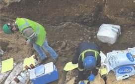
A mix of on-feet teams and teams in boats will travel across the delta territory gathering data about water level, composition, vegetation structure and more

The team will also use planes to gather data on the slope of water on the Delta at different times of day as well as its distribution during high and low tide
According to NASA, the Delta has been losing the equivalent of around one American football field per hour since the 1930s, which poses a growing threat to to surrounding area.
The project was originally proposed in 2015 and after four years of planning and preparation, the team will finally set out in April to start gathering data.
They’ll use planes with synthetic-aperture radar sensors to measure the slope of the Delta waters at different times of day and tide height.
Boats will also be used to collect water samples, sonar readings, and other data, and on-foot crews will walk across the wetlands gathering water levels and measuring the structure of local vegetation and landmasses.


