Diagrams on the floor of an ancient house in Pompeii made using stones and tile fragments pay tribute to the skilful Roman surveyors and their sophisticated measurement tools
- Images from the House of Orion appear to depict tools of Roman town planners
- The planners, known as Agrimensores, used intuitive measuring instruments
- Researchers believe the house may have been used for town planning meetings
New archaeological excavations of ancient floors in the house of Pompeii reveal enigmatic images that appear to pay tribute to the urban planners of the day.
Researchers believe excavations uncover the first ever depiction of the Roman land surveyors’ clever measuring tool, known as a groma.
Excavations are taking place in the Casa di Orione, or the House of Orion, amid the remains of the ancient city in the province of Naples, southern Italy.

This image appears to be a depiction of a primitive badge or logo of the group and principles of Roman land planners, known as Agrimensores

The new images have been located in concrete floors in the pavements of the House of Orion in the ancient city of Pompeii, marked by 1 and 2
As well as two mosaics representing Orion, the hunter in Greek mythology, three enigmatic images appear to reference the Roman Agrimensores, the name given to Roman ground surveyors and planners.
The images were created by embellishing cement paving stones within the house with small stones or tiles.
One such example features a square inscribed inside a circle, which is cut by two perpendicular lines, one of which represents the longitudinal axis of the house.
The image is suggestive of a compass rose and is strikingly similar to one used in ancient manuscripts to illustrate how Roman Agrimensores divided spaces during planning.
Researchers propose that the square in a circle, which would have been the first image visible to any visitor upon entering the house, was an icon or primitive badge representing the duties of the Agrimensores and their principles.
They also speculate that the house may have been used for meetings or that the house owner had belonged to the gromatic’s guild.
Another image shows a circle with an orthogonal cross inside connected by dots to a straight line with a base, which has been interpreted as a depiction of groma, the Agrimensores’ working tool.

Researchers believe the first ever depiction of a groma (right) has been uncovered in the remains of the House of Orion

Groma, ancient tools used by the Romans to measure precise angles in the land for planning purposes, were actually rather sophisticated for the time
The last image next to the probable groma illustration features five almost parallel segments which start from a common baseline, interpreted as the representation of a land-surveying project.
Medieval codexes, or scriptures, have passed on a collection of writings by the Agrimensores, which the researchers used to back up their summations.

Medieval scriptures show the work of the groma, which researchers used to compare the new excavation findings — in particular, a circle-cross nearly identical to the one just discovered
The complete interpretation of the images has been published in a paper by Massimo Osanna, director of the Pompeii archaeological site, and Luisa Ferro and Giulio Magli, of the School of Architecture at the Politecnico of Milan.
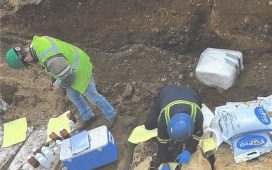
The excavation work is part of the Great Pompeii Project, an EU-backed initiative to restore the ancient Italian city.
A small section of the House of Orion was excavated between 1892 and 1893, but the house was only discovered in its completeness in December last year.


