Bronze Age monument discovered in Forest of Dean using airborne laser scanning could have been ritual BURIAL ground, archaeologist claims
- Dating back to 2,000 BC the ritual ring was found during a LiDAR laser scan
- Archaeologist Jon Hoyle discovered site, near Tidenham, Gloucestershire
- The ‘very significant’ Bronze Age monument was hidden in the Forest of Dean
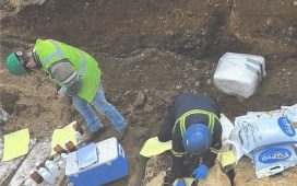
A ‘very significant’ discovery of a Bronze Age monument has been uncovered after being hidden under foliage in the Forest of Dean.
Dating back to about 2,000 BC the circular ritual ring was found during a LiDAR laser scan of the area.
The findings, known as a ring cairn, consist of a circular bank with limestone standing stones.
Archaeologist Jon Hoyle discovered the site, near the village of Tidenham, Gloucestershire, which he first believed could be a World War Two gun emplacement due to its ‘extremely circular’ nature.

Archaeologist Jon Hoyle said nobody knows precisely what ring cairns were used for. An artists impression of the 2,000 BC the circular ritual ring

Dating back to about 2,000 BC the circular ritual ring was found during a LiDAR laser scan of the area
This is the only Bronze Age monument of its type to be discovered in Gloucestershire, however the cairns are common in Derbyshire, Northumberland and Wales, said Mr Hoyle.
Mr Hoyle told the BBC: ‘It was very exciting. I was expecting to find quite a lot of new sites with the LiDAR, but nothing as interesting as this.’
Adding: ‘Nobody knows precisely what they were used for.
‘Some have been found in association with burials, and often there appear to be residues of charcoal in places like this, suggesting rituals that involved fire.’

This is the only Bronze Age monument of its type to be discovered in Gloucestershire, however the cairns are common in Derbyshire, Northumberland and Wales

Archaeologist Jon Hoyle discovered the site, near the village of Tidenham, Gloucestershire
The large ring is about 80ft wide and contains a circular bank formed with rubble that is 16ft wide.
White limestone standing stones were found on top of the bank, about 3ft high each.’
LiDAR (light detection and ranging) can be used to expose structures hidden by folliage or other structures by bouncing light off a target to measure distances and build a 3D map.

The archaeologist first believed the ring could be a World War Two gun emplacement due to its ‘extremely circular’ nature


