Back when I had no children and, consequently, the seesaw of life’s energy still tipped towards surplus rather than shortfall, I got into the habit of long, early morning runs. I was living in a built-up suburb of east Belfast, but one of the unappreciated and beguiling features of that complex city is the easy access to the beautiful and diverse countryside that rings it.
Keen to get off pavement and away from traffic, my heels took to the hills, following no particular route other than a vague plan to keep ascending. To my great delight I found a network of rough paths connecting glens, grassy hills, fields, pockets of woodland and quieter country roads, all within half an hour of jogging up from the city.
Fittingly – for the hills over the east of the city were the childhood playground of CS Lewis – it felt as if I’d discovered some Narnia-esque portal to another world. What I’d actually found was part of the Ulster Way, a 636-mile network of walking trails looping the circumference of Northern Ireland, which was first envisaged 75 years ago and, over the past year or so, has been revamped and re-mapped to mark this anniversary.

The intervening decades have been turbulent here, to say the least, and that the Ulster Way survived long enough to be reborn is remarkable. But not as remarkable as its actual birth. Access to the countryside in general is much more restricted in Northern Ireland than in mainland Britain: there are no national parks, far fewer public rights of way, and land ownership is much more fragmented with a patchwork of smaller farms and estates. Consequently, most off-road walking routes depend on the goodwill of numerous private landowners and alliances with groups such as local councils and the National Trust.
It’s a tricky balance in the 21st century, but imagine what it must have been like trying to convince rural people in Ireland in the 1940s that townies should be encouraged to roam their lands just for “exercise”. Across this unpromising backdrop strode the intrepid, irrepressible Wilfrid Capper.
Capper was a career civil servant but his greatest contribution to Northern Ireland was his passion for the countryside, and his voluntary work preserving and promoting it was decades ahead of the time and has proved priceless.
Prior to conceiving and developing the Ulster Way, he was also the instigator and driving force of a campaign to secure County Antrim’s breathtakingly beautiful White Park Bay from developers, which raised £15,000 from the public to buy the site and then hand it over to the National Trust, which still looks after it today. He founded the Ulster Society for the Preservation of the Countryside and served on its committee for nearly half a century, helping preserve many beautiful places that are today unspoilt canvasses for tourism campaigns and film and television projects such as HBO’s Game of Thrones.

But it’s for stitching together an unbroken walking trail through many of these landscapes that Capper is chiefly remembered. His own love of rambling, aligned with his campaigning to protect the few areas of rural access that all Northern Ireland people could enjoy back then, merged into his vision for the Ulster Way. It began after he walked the Pennine Way in 1946, and took him more than 30 years to realise the dream.
He almost single-handedly created what is one of the longest waymarked trails in the British Isles, first visiting, testing and mapping all the sections, then finding out who owned what and pleading with them to allow access. It’s difficult to imagine any public sector committee or professional legislators being able to achieve what he did. When his original route of 540 miles was first formally unveiled as the Ulster Way in 1979, he was the first to walk its entire length. He walked it all again more than a decade later at the age of 88.

Over the years, time and legislation caught up with much of the original route and some of the quiet country roads Capper tramped have become substantially busier and more dangerous. The promotion of the Ulster Way is now managed by Walk NI, which this month unveiled the remapped and revamped route.
Online there is a downloadable map and suggested itineraries with route descriptions, as well as a range of shorter walks that take in parts of the full route so it can be tackled in stages. The original, circular lap concept is retained, but the full loop is now divided into “quality” and “link” sections. The link sections are mainly along busy public roads, so walkers are advised to use public transport here and prioritise the quality sections for rambling.
Decades after I first fell upon that old network in the Castlereagh Hills, I wanted to reconnect with the Ulster Way and pay tribute to the visionary ideals of Capper. Now with a young family and with the energy seesaw consequently more commonly tipped to shortfall, walking the whole route wasn’t feasible. But where better to take in Capper’s contribution than a hike amid the splendour of White Park Bay, where, thanks to him, free access to this extraordinary stretch of coast is the priceless birthright of us all?

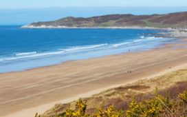
The National Trust maintains a car park above the bay, just off the main Ballintoy to Dunseverick Road. I walk down the path from there and am immediately struck by the true splendour of what Capper secured for the public. Three miles of ivory sand curved around the bay in front of me, twinkling in the late summer light and getting brushed clean by weighty rollers from the north Atlantic.
To the east, the dark green fields of north Antrim stretch over the hills and down to the shore. The local cows famously don’t distinguish between field and beach and wander freely across the natural grass borders, perhaps as enthralled as we are by the fine texture of the almost powdery sand. The bucolic vista to the east is upstaged by the drama of the cliffs and huge boulders to the west and the hint of a village at the far end of the bay, before it ends in a dark and steep rocky outcrop further along the coast.
I knew there was an arch cut through that rock that had long facilitated an off-road path along the shore that runs to Dunseverick Castle, the Giant’s Causeway and on to Portballintrae. This is one of the most celebrated sections of the Ulster Way, and rightly so. It’s a remarkable trail, encompassing a world heritage site and numerous areas of special scientific interest.

At the western end of White Park Bay, I hop over boulders and across rock pools, nervously checking the capricious sea in the neurotic fear that it might break the habit of eternity and rush in all at once, hours ahead of the timetable I had carefully checked while planning the walk. (It can be impassable at high tide when the waves can crash right into the cliffs.)
Clambering under a cliff head at the end of the beach enhances the otherworldly impact of arriving in Portbraddan. It’s like stepping into a film set. A cluster of white cottages set around the remains of an old salmon-fishing harbour lean together in the shadow of the cliffs behind and to the side, all facing out over the water and protected from the ferocity of the waves by the natural curve of the coast. There is a thin road down to the hamlet but it nonetheless feels gloriously isolated, all the more so in the stormy depths of winter, I imagine.
Isolated it may be, but sadly not immune to the whims of developers or property owners. Portbraddan was once home to the world’s smallest church, St Gobban’s, a much-loved landmark in these parts, which measured 3.5 metres by 2 metres and was created in a former calf barn by a church minister. Its popularity led to its downfall because some locals disliked visitors disturbing their peace and the new owner had it bulldozed.

It is from such uncharitable acts that Wilfrid Capper spared this area and many other places, and as I pass the site where the church stood and find the public path past the little harbour and around the cliffs to the arch, I quietly thank him.
The clash and combination of sea and stone around these headlands eclipses the creation or destruction of human-made objects in any case. It is a remarkable geological wonder and a privilege to walk through it all. The blue and yellow markers of the Causeway Coast Way are your guide – the 33 miles of this trail are included as one of the quality sections of the Ulster Way – and they point you across basalt bays and fields, around rock formations and up and down cliff walks. On clear days, the Scottish coastline is visible across the water, a reminder that the two regions were once united as the ancient kingdom of Dalriada, ruled over by Fergus the Great in the fifth century.
Fergus’s “homeplace”, as we say in these parts, was at Dunseverick, just a mile and a half along the coast from Portbraddan, where he built a castle on a remarkable natural rock platform that extends into the sea like a giant thick thumb. Ruins still stand, a stacked stone sentinel of a former kingdom which, like everything else around here, could never outlive or outshine the inestimable power of the natural forces that constructed its setting.
The evening sun is dropping behind the castle as I turn to retrace my steps back to White Park Bay. From a hillock overlooking the gentle Dunseverick Falls, I watch the sky melt through a full rainbow range. A crystal cascade runs over a glistening green carpet of moss and black basalt and is swallowed by the thundering froth of the sea below.
It’s an awe-inspiring place and, even set within the context of the Ulster Way’s magnificently varied and beautiful collection of walking trails, this is a standout section, hopefully now preserved for posterity. And for that, and the rest of it, Mr Capper, we salute you.